Map magic
Since my sabbatical research includes visiting colleges and universities around the U.S. and Canada, to get things rolling I needed a map. The easiest and in some ways most satisfying approach would be to get a big paper map and stick colored pins into it to mark possible visit locations. If I'd have had a big map and pins handy I'd have probably done it. But since I didn't, I thought about alternatives.
The most obvious alternative was a Google Map. I could add colored icons to a map of the U.S., giving each a label with the address of the school, contact person and phone number, etc. Later I could use the map to find the places when I visited.
Great! I went to Google Maps and created a new map. I began adding turquoise icons to the map, putting contact information in the label. This worked, but I soon realized that it would be much more useful to have the label information in a spreadsheet. Then I could sort it by state, school name, whatever I needed.
OK, I fired up Excel and started putting information into it. I began copying information from my SurveyMonkey results but again, before too long I realized that this was kind of silly. If I kept at it I'd end up with a spreadsheet with the information I needed, but no map. I'd have to somehow put the information back into a map at some point. Surely there was a way to have the computer do the work on this. I figured the best way would be a Google-based solution, so I moved my spreadsheet info into a new Google Doc called "Sabbatical visit list." Using the online Google Docs instead of Excel meant that I could access and work on the spreadsheet anywhere I could get online.
Now, to figure out how to make it all work together I simply googled: "address from google doc to map." I immediately got a website that would make this magic happen, but my spreadsheet was missing two crucial bits of information: the latitude and longitude of each location—its geocode. I had no idea how to get this information, so I googled "how to geocode location."
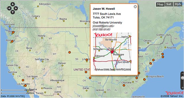
Bingo! There was www.Geocoder.us that would do one location at a time (which would take a while) but better yet there was www.BatchGeocode.com which would take the entire spreadsheet, figure the geocode for each location and—get this—create a map with the locations marked and the other information stored as clickable notes. You see the results below. Each orange dot is a location I mapped; clicking on a dot brings up the info panel with a more detailed map.
![]() Where do you call home? Add your comment by clicking below.
Where do you call home? Add your comment by clicking below.
Top |
|
![]()